Ogden Valley Trails & Camping
Trails and Camping
Uinta-Wasatch-Cache National Forest
The Uinta-Wasatch-Cache National Forest surrounds Ogden Valley. Most trailheads are free to access, while developed campgrounds charge fees.
Popular recreation areas include Monte Cristo, South Fork and Anderson Cove. Visit the U.S. Forest Service for trail information, campground reservations and recreation details.
How to Get There?
The main routes into Ogden Valley are SR-39, SR-158, and SR-167.
- SR-39: most direct route into the valley from I-15, bringing you straight to Pineview Reservoir and up to Monte Cristo Highway. Vehicles longer than 50 feet are not permitted to travel in Ogden Canyon (between the canyon mouth and Pineview Dam).
- SR-167: accessed via I-84 (Weber Canyon, Exit 92), a smooth climb over the mountain ridgelines into the south end of Huntsville.
- SR-158: branches off SR-39 near the Pineview Dam lining the western and northern arms of the reservoir through Eden.
Local favorite: North Ogden Divide – this steep county road connects North Ogden directly to Liberty. Large vehicles should use SR-167 instead of North Ogden Divide. The county road is narrow with blind switchbacks, steep drop-offs, and frequent rockfall.
Monte Cristo Recreation Area
The large paved lot at the SR-39 winter closure gate remains open in the summer and provides a staging area for trucks hauling ATVs and side-by-sides.
Parking is free for day-use, and vault restrooms are available. If you’re staying at the official Monte Cristo Campground, your site fee covers your primary tow vehicle.
Extra vehicles or standalone utility trailers will require an additional daily fee and must fit completely on the designated campsite spur without encroaching on the campground road.
North Fork Park
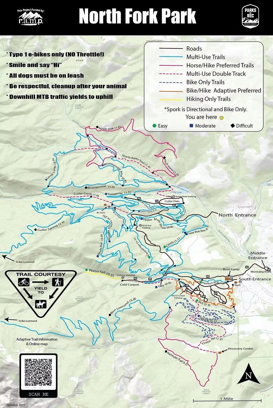
North Fork Park is a Weber County park in Liberty offering year-round recreation. It is also an International Dark Sky Park. It functions as a year-round hub for eco-tourism, mountain recreation, and wildlife preservation.
Off-Highway Vehicles (OHVs), ATVs, and UTVs are not permitted inside North Fork Park.
How to get there
Accessing North Fork Park in Liberty requires traveling into the Ogden Valley via I-84, SR-167, SR-39 or SR-158 before connecting to local county roads. Once in Eden, travel past the Liberty crossroad for approximately 2.5 miles.
Parking
North Fork Park offers free day-use parking via three entrances off North Fork Road in Liberty.
- South Gate: The main access point for mountain bikers and trail runners, featuring a large gravel lot. In winter, this lot is plowed to serve as the primary staging area for Ogden Nordic’s groomed cross-country, snowshoe, and fat-tire biking trails.
- Middle & North Gates: These entrances lead to campsites and pavilions. Small pullouts near trail crossings allow users to access higher-elevation loops without climbing from the South Gate.
Trails Foundation Northern Utah
The non-motorized trail networks in the Ogden Valley area are available to both hikers and mountain bikers, featuring interconnected loops that span from low valley canyons to high alpine ridges.
The trail network exists due to a collaborative effort between the Uinta-Wasatch-Cache National Forest (U.S. Forest Service) and the Trails Foundation of Northern Utah.
 For information about these trails, visit the Trails Foundation of Northern Utah website at https://www.tfnu.org/
Ultimate Trails Guide
Middle Fork Wildlife Management Area
Middle Fork Wildlife Management Area is managed by the Utah Division of Wildlife Resources (DWR). Public access is available during open seasons. Visit DWR for recreation rules and seasonal information.
How to get there and where to park
From Huntsville, head north on 7800 East. Where 1900 North connects from the west, you will see the official Middle Fork WMA entrance sign. Follow the access road north and then east into the main parking lot.
Keep in mind: Motorized vehicles are only permitted on explicitly marked, designated public access roads (like the main entrance road to the parking lot).
Campgrounds in Ogden Valley
The interactive map below highlights the locations of the campgrounds that are located in the Ogden Valley.